KML4Earth
Reference |
| © Copyright 2011 jasonm1 |
 Google Earth/Maps Icons
The following is a collection of icons Google makes available for Google Earth and Google Maps.
This is a useful cheat sheet showing all the standard icons to use in Google Earth, Google Maps, and other map related applications. All icons are PNG images and include standard symbols for weather, highway, roads, numbers, arrows, etc. The icons below are the official Google icons shown in one place for a handy reference.
You can insert the URLs below into Google Earth when editing the icon for a given placemark [see instructions]or use in the KML you create programmically.
http://maps.google.com/mapfiles/kml/shapes

![]()
![]()


![]()


![]()
![]()
![]()
![]()


![]()
![]()


![]()


![]()
![]()
![]()
![]()


![]()
![]()
![]()
![]()


![]()


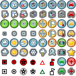
http://maps.google.com/mapfiles/kml/pushpin


http://maps.google.com/mapfiles/kml/paddle


http://earth.google.com/images/kml-icons/
![]()
![]()
![]()
![]()
![]()
![]()
![]()
![]()
![]()
![]()
![]()
![]()
![]()
![]()
![]()
![]()
![]()
Note: The track icons are treated special in Google Earth. If you specify to use the gx:Track extension as used for GPS-tracks and specify a Style using the http://earth.google.com/images/kml-icons/track-directional/track-0.png icon (shown above) then the icon is dynamically changed to appropriate icon using the computed compass heading from the previous position. The URL http://maps.google.com/mapfiles/kml/shapes/track.png can also be used in KML for the track icon style for the same behavior, but in this case the URL itself doesn't resolve if accessed directly in a web browser and results in a HTTP 404 not found error.
http://maps.google.com/mapfiles/kml/pal2


http://maps.google.com/mapfiles/kml/pal3


http://maps.google.com/mapfiles/kml/pal4


http://maps.google.com/mapfiles/kml/pal5


http://maps.google.com/mapfiles
![]()


![]()
![]()


Other misc icons
![]()


Notes:
1. The first four groups of icons above (shapes through kml-icons) are the "standard" Google Earth icons. These icons are part of Google Earth application and included in the client distribution. Each of these icons have a default HotSpot orientation specified so the client knows where to place the icon with respect to the coordinates on the map. The origin of the coordinate system is in the lower left corner of the icon such that x=0, y=0 refers to the lower-left pixel in the icon image.The pushpin icons, for example, have the hotspot defined at the lower-left corner of the icon.The default hotSpot for custom icons in KML is x=0.5, xunits=fraction, y=0.5, yunits=fraction which places the center of a custom icon at the point's location. If the custom icon implies an implicit hotspot such as having an arrow or some such callout then an explicit hotSpot *must* be defined in the IconStyle otherwise end-users may incorrectly assume the actual location relative to the icon is at a different place on the map.
Adding the pushpin icon to a Placemark automatically creates an IconStyle with following settings:
icon hotSpot iconStyle defintion Notes <hotSpot x="20" y="2" xunits="pixels" yunits="pixels"/> Hotspot at lower-left of icon at pin tip <hotSpot x="54" y="42" xunits="pixels" yunits="pixels"/> Hotspot at upper-right of icon at arrow-head tip <hotSpot x="32" y="1" xunits="pixels" yunits="pixels"/> Hotspot at bottom-center of icon
2. The pal2 through pal5 icon groups were used by earlier versions of Google Earth and no longer part of the core icons. In fact, if you create a custom icon style with any of the pal image URLs then Google Earth will automatically remap the URL to one of the standard icons such as the following:
3. The standard icons, which are shown in the icon chooser dialog in Google Earth (shown as thumbnail below), are accessed locally (and not fetched over network). These standard icons include those in the shapes, pushpin, and paddle icon groups (e.g. http://maps.google.com/mapfiles/kml/shapes/bus.png).
=> =>
These URLs are treated as URIs (or aliases) to the corresponding file stored locally which is especially important for closed/standalone environments where the domain maps.google.com cannot be accessed but the icons are still displayed. That is one of the benefits of choosing one of the standard Google icons as opposed to custom icons.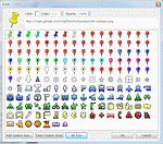

|
4. Google Earth 3.0 used a set of 256x256 images for its default icons with URLs of a special form: root://icons/....
Within Google Earth program files location was a set of PNG images (palette-1.png, palette-2.png, etc.) from which KML can refer
to a specific icon with an x and y offset and height/width of 32-pixels.
Example: See palette-4.png image illustrated on the right. To use the red-square iconThis root:// notation is no longer supported in Google Earth and you must use the proper URL for the icon (e.g. http://maps.google.com/mapfiles/kml/pushpin/ylw-pushpin.png). |
palette-4.png |
See Also
https://mapicons.nicolasmollet.com/ has a large collection of map icons.
Google Earth (TM) and Google Maps (TM) are registered trademarks of Google Inc. KML4Earth is not
affiliated with Google.
All image screenshots from Google Earth are Copyright Google.